
Finding Albany Streets by Address
An Albany street directory works best as a reproducible chain of parcel records. Start with a number and street, determine the municipality, and save the SBL or print key that the assessment result gives you. That identifier can connect the address to a map polygon, a tax map, and a recorded document. The final result is a set of dated public facts about parcels and recorded parties, not a claim about every person connected with a street.
- Run the street through Albany County PROS, using Street Finder and the municipality when possible.
- Write down each parcel's situs address, current owner field, mailing field, and SBL or print key.
- Open the same location through the Albany County GIS mapping route and compare the parcel outline with the road.
- Use the owner, book and page, or legal description in the County Clerk index to locate the recorded deed trail.
- For earlier residents, pair the address with a Street Guide, historical voter book, map, or directory volume.
Note: Preserve the search date and municipality because the same road name can cross several Albany County jurisdictions.
Albany Street Directory in PROS
PROS is the strongest whole-road starting point in the Albany street directory. The quick form takes Street Address, Tax Map number or SBL, Owner Name, Street Finder, and Municipality. Street Finder lists county public roads and can be combined with a number. For address searches, the county instructions say to use the number plus street and omit the suffix. A broad substring can return more than one road, so the parcel identifier matters.
The advanced PROS screen adds property and sale filters such as municipality, neighborhood, street, owner, property class, sale date, size, assessed values, year built, bedrooms, bathrooms, and condition.
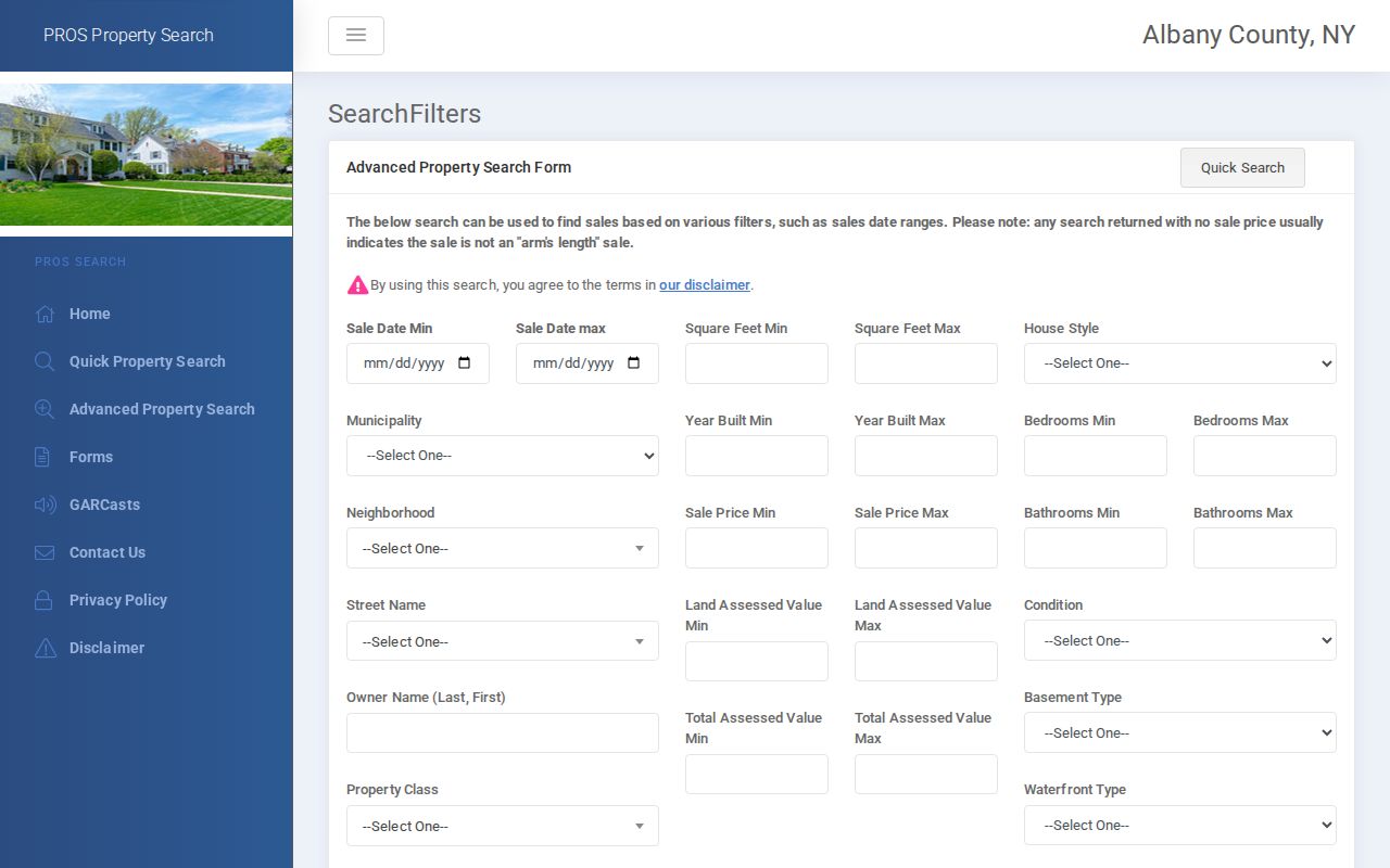
The advanced view can narrow a road to a documented property pattern, but it does not turn a street search into a list of household members.
| Albany PROS field | Documented use | Input note |
|---|---|---|
| Street Address | Find a specific parcel | Number plus street, omit suffix |
| Tax Map # / SBL | Fix an ambiguous address to one parcel | Use the tax-map identifier |
| Owner Name | Find current or prior-owner matches | “=Williams” is the documented exact-last-name form |
| Street Finder | Return parcels on a chosen public road | Dropdown, optionally paired with a number |
| Municipality | Separate a road across local boundaries | County city, town, or village filter |
Albany Street Parcels and SBLs
The SBL is the local Section-Block-Lot style parcel identifier. A tax map or parcel card may also call it a print key, account, or municipal parcel number. A street number can change, repeat across a road, or be recorded differently in an old source. The SBL is the better bridge from a current street directory result to the map, tax roll, and deed description.
A parcel card can show owner name, situs, tax mailing address, assessment values, property class, lot data, building characteristics, and a book/page reference. The mailing address is not proof that the owner is physically at the parcel. It may be a post office box, an office, a representative, or an address outside the county.
- Parcel
- A mapped property unit tied to assessment and tax-map records.
- Situs address
- The physical street location of the parcel.
- Plat
- A filed map that can connect a lot or subdivision description to a mapped place.
- Criss-cross directory
- A reverse Street Guide that starts with a road and house number rather than a person's name.
Albany Street Map Parcel Chain
Use mapping to test the physical relationship between address records. The county mapping page links its interactive resources, and the state parcel service exposes geometry along with address, SBL, municipality, owner, valuation, acreage, book/page, and roll or spatial-year fields. Pan to the road, click a parcel, record its identifiers, then use the identifier in PROS or Image Mate. The map is visual assessment context, not a certified title record.
On a long Albany road, repeat the process municipality by municipality. The county contains three cities, nine towns, and six villages, and street names can continue through more than one local area. A street-based answer needs that boundary check before any records are combined.
Note: Layer names and live map controls can vary, so confirm the active viewer's tools instead of assuming a particular selection or buffer feature.
Albany Street Record Layers
Address-keyed Albany records work as a sequence. The current roll anchors a parcel. GIS establishes its map relationship. A deed supplies recorded title parties and the legal description. City permit records can date work. Historical street guides and voter volumes place names at an address in their own dates. Each layer answers a different question, so no one column should be treated as a complete street directory.
| Street record layer | Albany custodian | What it can establish | Access route |
|---|---|---|---|
| PROS / assessment roll | Local assessing unit and county tax service | Owner, mailing and situs addresses, SBL, values | Free web search or local roll |
| GIS parcel map | County / NYS GIS | Polygon, address, SBL, map setting | Public viewer or parcel data |
| Deed or mortgage | County Clerk / Hall | Grantor, grantee, legal description, recording | Online current images, older index and books |
| City CSS record | Buildings and Regulatory Compliance | Permit, code case, ROP, registry status | Live address portal, phone fallback for older documents |
| Street Guide and voter book | APL / Hall of Records | Historical occupant or voter address layer | Print, film, archive, and request channels |
Albany Deeds Along Streets
Once PROS yields a parcel, the deed chain becomes party and legal-description research. The County Clerk's online record service states that deed and mortgage images are online from 1980. A vendor help segment describes older deed index information from October 20, 1908 through January 4, 1980. Beyond that, the Hall of Records holds the Public Grantor/Grantee Index from 1630 to 1940 and archival deed books.
Read a deed's grantor, grantee, recording date, book/page, and legal description. Then search the prior grantor as an earlier grantee for the same lot. Old descriptions can name lot lines, adjoining owners, a plat, or a former street name rather than a modern number. The index is therefore a route to a document, not a final answer.
The County Clerk's search room, paid copy process, and Hall holdings are the fallback chain when a web image ends. For an address going backward through time, the distinct deed method is covered further in the Albany previous residents search.
Albany Street Permits and Codes
City of Albany address research can add a work-history layer through the Citizen's Self-Service portal. A property search may show construction permit status, inspector, permitted work, Residential Occupancy Permit status and unit count, code cases, and several registry programs. Result attachments can include permits, placards, certificates, and inspection records where posted. The city warns that documents before 2023 may not be online.
The City Citizen's Self-Service portal information describes the live address route and the older-record caveat.
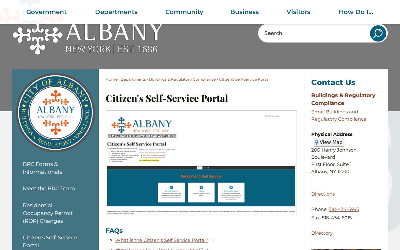
The archived permit method is different. Hall guides describe yearly 1909-1986 indexes filed by the street's first letter, with original permits arranged numerically. Save the year and permit number before asking for the original file.
Albany Street Guides and Voters
For a historical address, Albany Street or House Guides provide the reverse directory layer in 1895, 1896, and 1914-present. They are alphabetical by road and then by house number. A listed occupant can then be looked up in the alphabetical portion for occupation or business context. The library's long city-directory run, the Hall, the New York State Library, microfilm, and digitized collections all provide access channels depending on the year.
Historical Hall voter volumes are also street organized: ward or election district, then street, number, and voter name, with party information in later books. Current voter lookup does not offer a street-wide browser and protected registrations remain unavailable. A historical directory entry and voter volume can support a dated address research trail, but neither proves a modern household list.
Note: Directory Street Guides are not present in every year, so use the alphabetical section and nearby volumes to bridge the gaps.
Albany Street Name Changes
Albany's historical street directory has a local continuity problem: street names, wards, and boundaries changed. Hall research lists Central Avenue as Bowery, Madison Avenue as Wolf or Wolfe, Lake Avenue as Perry Street, Livingston Avenue as Lumber Street, and South Pearl as Cow Lane among the former names. Ward changes occurred repeatedly through 1966, and annexations changed municipal custody across the city's history.
This is why an old address should be searched by former street name, ward, and legal description as well as by the current number. The Hall guide recommends retaining spelling variants, question marks in handwritten assessments, and references to adjacent owners or lot dimensions. A missing modern-looking address can be a filing change, not an absence of evidence.
Albany Street Directory Limits
The Albany street directory can document parcels, recorded title parties, historical printed occupants, limited voter evidence, and address-keyed city work records. It cannot name unregistered household members, short-term visitors, utility customers, postal delivery customers, or DMV address holders. A ZIP or USPS standardized result only verifies mail routing. A recorded owner or tax mailing address must not be described as proof of who is physically at a property.
Lawful use. Albany street and address records are for lawful personal research, family history, estate questions, civic verification, and record correction. Never use them to stalk, harass, intimidate, or harm anyone.
New York Address Confidentiality Program participants and confidential voters can legitimately have no ordinary public address result. Respect that boundary and use a record custodian's correction or safety channel when information is wrong or a person needs protection.